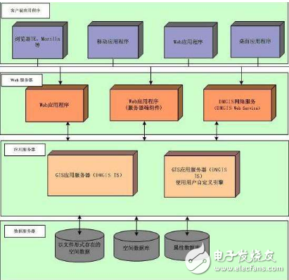
Broad: WEBGIS is a variety of geographic information systems that use Web technologies.
Narrow sense: WEBGIS is a geographic information system that connects its components through web technology. WebGIS is a distributed information system with at least one server and client.
Advantages: 1 Widespreadness of communication 2 Multiplicity of users 3 Better cross-platformity 4 Low cost of average cost 5 Ease of use for end users 6 Uniformity of update 7 Extensiveness of application 2. Basic framework (thin, Fat client, balance mode (example)
Thin: The client generally takes on fewer tasks and is mainly responsible for sending requests to the server.
Fat: Assign more tasks to the client, mainly by installing the corresponding web browser plug-in on the client computer or by using the client-side local application.
Best mode: divide the functions in the project into three basic components: the base map, the operation layer and the task.
WEB-GIS featuresGlobalized server applications: Internet users of any WWW node in the world can access various GIS services provided by WebGIS servers, and even global GIS data updates.
Really popular GIS: Due to the explosive development of the Internet, Web services are entering thousands of households, and WebGIS provides more users with the opportunity to use GIS. The popular WebGIS platforms are:
ARCIMS; Mapgis IMS; Super Map IS; TopMap
World; MapXtreme and other mature products at home and abroad. WebGIS can be browsed, queried using a generic browser, or plug-in, AcTIveX control, and Java on the browser.
Applet's access to WebGIS features, browsers and these plug-ins are free and easy to access, greatly expanding the range of potential users of GIS. In the past, GIS has become a professional tool owned by a few experts because of its high cost and technical difficulty, and it is difficult to promote it.
Good scalability: WebGIS is easy to integrate seamlessly with other information services on the Web, enabling the creation of flexible GIS applications.
Cross-platform features: Before WebGIS, although some vendors provided corresponding GIS software versions for different operating systems (such as Windows, UNIX, Macintosh), none of the GIS software really has cross-platform features. And Java-based WebGIS can do "one-time programming, running everywhere
(write once, run anywhere), to make the cross-platform features come to the fore.
According to the current WebGIS architecture, there are two main types:
1. Picture-style WebGIS is also called raster map, and can also implement vector map. Currently, it mainly uses VML.
2. Vector map based on controls. (AcTIveX, Java Applet)
Both developments have their pros and cons. In particular, there are many limitations based on controls. Since the release of Google Maps, tiled maps have become more popular!

For the 132kV Oil Immersed Power Transformer, we can produce capacity upto 180MVA. We use the best quality of raw material and advance design software to provide low noise, low losses, low partial discharge and high short-circuit impedance for power transformer.
Our power transformer are widely used in national grid, city grid, rural grid, power plant, industrial and mining enterprise, and petrochemical industry.
132Kv Transformer,132Kv Power Transformer,132Kv Power Transformer With Oltc,132Kv Transformer With Oltc
Hangzhou Qiantang River Electric Group Co., Ltd.(QRE) , https://www.qretransformer.com
